
DIRECTIONS TO GROUNDS
A new section of the site (although we did ask for directions last season and got a poor response). Teams please note, if you do send in directions, please could you bare in mind teams will be travelling from possibly North, South, East and West to your venue. Try to include as many landmarks (Pubs!), that people can ask for if they get lost.
Directions Are Listed in Club Order:
A C BLACKBURN - BAE SYSTEMS Samlesbury - MAP
ACCOUTRE FC - Witton Park Mini Soccer Pitches, Blackburn - MAP
Blacksnape Playing Fields, Darwen MAP
AKZO NOBEL JUNIORS - Witton Park Mini Soccer Pitches, Blackburn - MAP
Blacksnape Playing Fields, Darwen.
BARROWFORD CELTIC - Bullholme Playing Fields, Barrowford
BAXENDEN VILLA - Hollins School, Baxenden ,-
BELVERDERE JUNIORS - Directions Required
BLACKBURN UNITED - Pleckgate Playing Fields, Blackburn - MAP From M65, take Whitebirk turn off (JUNCTION 6).Take turning towards retail park/Brownhill. Retail Park (MFI, CURRYS, PC WORLD etc) should be on your Right hand side. Carry on straight ahead at traffic lights, and again at a second set of lights until you reach Brownhill Roundabout. Go straight ahead at roundabout onto Brownhill Drive. You will come to a set of traffic lights with a pub (Knowles Arms) on your left hand side. Turn Left onto Pleckgate Rd, travel up onto pleckgate rd and entrance to playing fields is on your right hand side. MAP
BORROWDALE UNITED - Barden High School, Burnley.-
Come off the M65 at J8, turn left and go down the hill towards Padiham. At the traffic lights, go straight on and straight on again at the next set - you are now on the A6068 (Padiham by-pass), signposted Fence and Barrowford. When you get to Fence, turn right (just after the speed camera), signposted Burnley (Greenhead Lane). Go down the hill, over the river and up the other side over the canal, past Barden Mill, under the railway, take the 2nd right turning to arrive at the main entrance to the Barden School sports facilities. There's plenty of parking and the pitch is behind the astroturf. A common error is to take the 1st right and arrive at the main entrance to the school where there is no access to the sports facilities
CLITHEROE WOLVES - Eddisford School-
Roefield Playing Fields -
Head
for Clitheroe and the A59 take the first turning off at the roundabout
and head for the town centre. You come to a mini roundabout and go straight over
it on to another mini roundabout near the BROWN COW pub go straight over and to
the top of the road. Turn left at the ABBEY NATIONAL down PARSON LANE. Go
straight down and over a mini roundabout over the railway bridge keep on
this road and go past the HORSESHOE PUB on the left straight down the road and
past the KINGS ARMS on the right keep going on this road past VANTAGE car
showroom and LOW MOOR CHURCH about 800 yards past the church Roefield playing
fields are on your right with car parking on your left.
CLIVIGER COLTS - Mount Lane, Cliviger -
CONSTABLE LEE F.C - Marl Pitts, Rawtenstall
FENISCOWLES ST PAULS - Feniscowles Memorial Ground, Blackburn - MAP
FULLEDGE COLTS - Morse St, Burnley -
Gt HARWOOD ROVERS - Wilsons PF, Gt Harwood - MAP
Memorial Park, Gt Harwood -
HUNCOAT UNITED - Huncoat Primary School - Map
Peel Park, Huncoat -
Bolton Avenue, Huncoat -Map
J.F.C DYNAMOS - Witton Park, Mini Soccer Pitches, Blackburn - MAP
Pleckgate Playing Fields, Blackburn - MAP From M65, take Whitebirk turn off (JUNCTION 6).Take turning towards retail park/Brownhill. Retail Park (MFI, CURRYS, PC WORLD etc) should be on your Right hand side. Carry on straight ahead at traffic lights, and again at a second set of lights until you reach Brownhill Roundabout. Go straight ahead at roundabout onto Brownhill Drive. You will come to a set of traffic lights with a pub (Knowles Arms) on your left hand side. Turn Left onto Pleckgate Rd, travel up onto pleckgate rd and entrance to playing fields is on your right hand side. MAP
JUNIOR CLARETS - Details Required
KNUZDEN YOUTH - Crosshills School, Blackburn - From M65 - Take Whitebirk turn off towards Blackburn. McDonalds and The Red Lion Pub should be on your left hand side. Carry on up Whitebirk Road until Intack Traffic lights(Intact pub on right hand side). Go Straight through traffic lights onto Shadsworth Road (Watch out for speed cameras!!!). You will come to a mini roundabout, carry on straight ahead continuing up Shadsworth Road . You will come to a second mini roundabout, go straight through and immediately to your right is the entrance to Crosshills School. - Map
Pleckgate Playing Fields, Blackburn - MAP From M65, take Whitebirk turn off (JUNCTION 6).Take turning towards retail park/Brownhill. Retail Park (MFI, CURRYS, PC WORLD etc) should be on your Right hand side. Carry on straight ahead at traffic lights, and again at a second set of lights until you reach Brownhill Roundabout. Go straight ahead at roundabout onto Brownhill Drive. You will come to a set of traffic lights with a pub (Knowles Arms) on your left hand side. Turn Left onto Pleckgate Rd, travel up onto pleckgate rd and entrance to playing fields is on your right hand side. MAP
LANGHO JUNIORS - Rydings FC, Longsight Rd, Langho
NELSON FC - Directions to Swinden Playing fields, Cravendale Avenue, Nelson: - MAP
Follow M65 eastbound towards Colne until the very end. At the large roundabout turn right onto Whitewalls Drive. At next roundabout go back on yourself in the other direction down Whitewalls Drive. Take your first left, into Regent Street. Carry on until you get to your first right turn with houses on. This is Cravendale Avenue. Carry on down Cravendale Avenue until you reach the second speed ramp. Immediately after this speed ramp is a small lane on the right between some houses. Go down this alleyway and the changing rooms and car park are there. Playing fields are across the bridge.
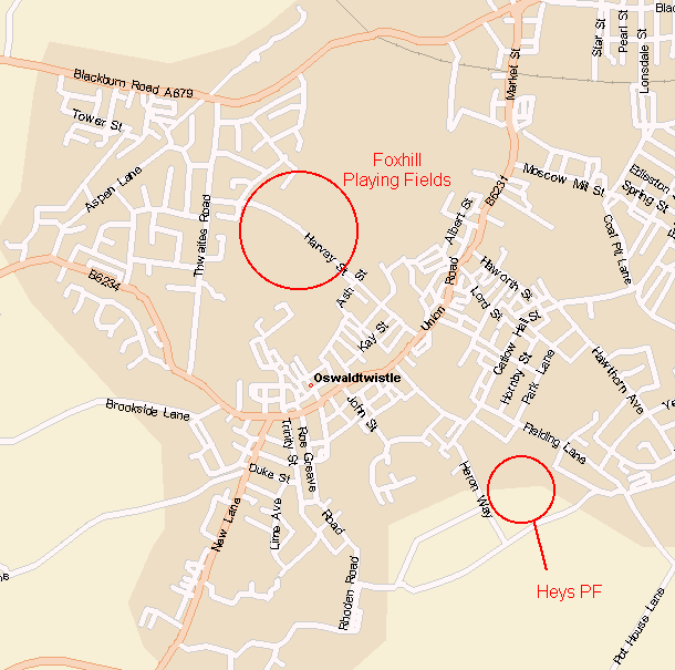
OSWALDTWISTLE JUNIORS - Foxhill Playing Fields, Oswaldtwistle. MAP
Heys Playing Fields, Oswaldtwistle - MAP
OSWALDTWISTLE RANGERS - Foxhill Playing fields, Oswaldtwistle - MAP
OSWALDTWISTLE UNITED - Foxhill Playing fields, Oswaldtwistle- MAP
PADIHAM UNITED F.C - Details Required
PARK LANE RANGERS - Beardwood High School, Blackburn - Map
PENDLE FOREST - Swindon Playing Fields, Barrowford
READSTONE UNITED - Read School, Read
St Leonards School, Padiham
RISHTON UNITED JFC - ST Charles School Rishton -
ST Peters/ Pauls School Rishton -
Primetime Rishton -
ROSSENDALE VALLEY - St Peters Avenue, Haslingden-. From Accrington/Hyndburn:Follow the A56 until the turn off marked Rawtenstall/Todmorden,at the traffic lights turn left up Manchester Rd.Travel for approx half a mile before turning left into St.Peters Avenue.the ground is on your left
Haslingden Sports Centre
ST JOSEPHS - Livingstone Rd, Accrington - From Accrington Town Centre: Carry on up Whalley Road (Signposted Clitheroe). Sraight through traffic lights at Victoria Hospital (Half a mile from town centre). Within half a mile from Victoria Hospital turn right onto livingstone Road. The ground is next to Accrington Stanley F.C
From Clayton Le Moors - At Traffic Lights in centre (By L Champ Funerals) take road into Accrington. After half a mile go straight across at Greyhound Pub. Within a quarter of a mile turn left into Livingstone Road, Just after Crown Pub.t
Wilson's Playing Fields, Clayton Le Moors
WALMSLEY FC -
WEST END CYC - Green Lane, Blackburn - MAP - Head towards Ewood Park (Blackburn Rovers) on Bolton Road, upon aproaching Ewood go into right hand lane of Dual carriageway. At Traffic lights you will go straight ahead onto a second set of traffic lights (McDonalds should be on your left hand side). At Second set of lights go straight ahead onto livesey Branch rd. Carry on Livesey Branch rd, Past Browb Cow Pub (Left) Moorgate Pub (Right). Keep on Livesey Branch rd until you approach a Schhol on your left hand side (St Bedes, Turn Right before you reach the school at junction, onto Green Lane. Travel down Green Lane until you reach Green Lane Community Centre on left hand side. Pitch behind community centre..MAP
WILPSHIRE WANDERERS - Salesbury Memorial Hall - From Whitebirk Roundabout (M65 junction 6) head NW on A6119. At Brownhill lights turn right on A666 towards Whalley and Clitheroe. At second set of lights turn left on B6245 signposted Ribchester. After ½ a mile Lovely Hall Lane bears right by the church. Stay on the B6245 and take the third driveway on the left. (If you reach the Bonny Inn, you’ve gone too far.) The car park is to the right of the hall, the pitch is on the left of the hall.
Pleckgate , Blackburn - From M65, take Whitebirk turn off (JUNCTION 6).Take turning towards retail park/Brownhill. Retail Park (MFI, CURRYS, PC WORLS etc) should be on your Right hand side. Carry on straight ahead at traffic lights, and again at a second set of lights until you reach Brownhill Roundabout. Go straight ahead at roundabout onto Brownhill Drive. You will come to a set of traffic lights with a pub (Knowles Arms) on your left hand side. Turn Left onto Pleckgate Rd, travel up onto pleckgate rd and entrance to playing fields is on your right hand side. MAP
WOODBANK JUNIORS - From the M65 Junction 8 take the A56 towards BURY. Stay on the A56 until it is about to run into the M66 Motorway. DO NOT go onto the M66 Motorway. Take the exit signposted A676 (Ramsbottom). At the roundabout at the end of the sliproad, once again, take the A56 (BURY). After approximately 1